Hyposemtric map is a map of topography that uses color sequence by filling in the spaces between contours usually with green, yellow, orange and blue. This is a hyposemtric map of the moon.
A hypsometric map is a map that shows the configuration and the height of a land and its surface. This hypsometric map is of the Aral Sea and its surroundings. Mountains, rivers and other land types of show in this type of map.
An isotach map is a line on a map connecting points of equal wind speed. This map is measuring jetstreams in the west and midwest states. It shows the wind speed of these areas.
An isobar map is a map with imaginary line(s) that illustrate the equal barometric pressue. This mpa of the United States shows barometric pressure pattern.
Doppler radar is a radar tracking system that uses the Doppler effect to find the location and velocity of clouds, precipitation, and storms. This is a sample of Doppler radar of Canada.
Infrared photos care made with cameras that are sensitive to certain things like light and use a special kind of filtration. Infrared photos are used by the military and environmentalists among other groups. This is an infrared photo of Sabine Pass, Texas.
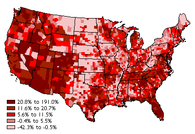
A nominal area choropleth map is a type of thematic map that illustrates data. This map
has different colors and patterns to highlight certain areas. This nominal area choropleth map
is the population of the United States from 1990-2000.